Showing posts with label Auckland walks. Show all posts

09 July 2015

Auckland walks: From the city to Mt Eden and back

Fancy a walk? Okay, then pull on those hiking shoes and grab some water ‘cause we’ll be pounding the pavements for about 9 kilometres and we’re going to head up a volcano so you might feel the heat.

At 196 metres, Mt Eden is the highest point in central Auckland so a great place for spectacular panoramic views over the city, its harbours and suburbs. And when we walk there, and back, from the central city, there’s a lot to see along the way, including a historic cemetery, two old churches, some street art, assorted historic buildings, significant places in Maori history, old villas and a huge park.

I’ve plotted our route on a map (just click on it to see it full screen) and numbered the points of interest along the way. These are just a few of the things that have caught my eye on past walks -- you will no doubt see other things that capture your interest and imagination.

1. A convenient place to start, and end, is at the corner of Symonds Street and Grafton Road, right in the centre of the University of Auckland’s huge complex of buildings. We could easily spend a whole afternoon exploring the university grounds … but that’s for another day. We’ll head up Symonds Street, past the towering blocks of student accommodation and offices and pause briefly for a look at Symonds Street cemetery. (For more on this fascinating place, check out my previous blog.) 


2. Church of the Holy Sepulchre
After a left turn at Khyber Pass Road, we find one of the historic highlights of our walk on the corner of Khyber Pass and Burleigh Street. The Church of the Holy Sepulchre dates from 1880 and is renowned for its wooden interior, one of the best in the world. Unfortunately, the only way to see that interior is to attend a Sunday service as the church is not open for public viewing.


3. Cityside Baptist Church
At the bottom of Burleigh Street, on the corner with Mt Eden Road, is another old church, not nearly so distinguished but with its own history and the most gorgeous little bell(-less) tower perched on top.


4. Snippets of Mt Eden history
After turning left along Boston Road, then right at Normanby Road, a glance to our right before we cross the railway line will bring a glimpse of some of Auckland’s street art, in this case the running squirrels of BMD. To our left is Mt Eden jail – not a place we want to enter – and further along Normanby Road, we find some historical links to Mt Eden’s past: the Colonial Ammunition Company's shot tower, the old bluestone building (now the CAC Bar & Eatery), and Normanby pub, to name a few.


The whau tree, from which this mountain takes its Maori name
5. Mt Eden
There are many paths up Mt Eden: sometimes I head up the dirt paths, sometimes I sweat up the steps old and new, sometimes I go up the roadway. It’s worth several visits to check the different routes as the trees and the views are all different. Maori named this volcanic cone Maungawhau (mountain of the whau tree), and archaeologists have discovered that as many as 3000 people lived on its slopes in the 1600s. We can still see the pits and depressions in the landscape, where kumara and taro would have been stored after harvest and houses would have nestled. And now we’re at the top, check out how deep the crater is. Impressive, eh? And look at the magnificent panoramic views – without a doubt, the best in Auckland.


6. Heading down
We’ll head back to the city by a different route. First, we veer off the road and down the steps bordering Government House. I used to think you might be able to get a sneak peek at visiting dignitaries from these steps but the trees are too tall and lush: many were planted as long ago as the 1870s.

We turn left at Mountain Road and our stroll takes us past some very lovely and very expensive real estate, some charming historic villas, past Mercy Hospital and a plethora of villas that now house medical specialists, and then alongside the splendid Spanish Mission-style buildings of Auckland Grammar School.  


7. Auckland Domain
After crossing Khyber Pass Road, we head up the appropriately named Park Road towards Auckland Domain. Today we’re just going to walk past the Duck Ponds and down the pohutukawa-lined Centennial Walkway but the Domain really deserves more time to explore. Check out some of its highlights in my earlier blog here

Once we exit the Domain, we simple head up the slope opposite, up Grafton Road, between the buildings, old and new, of the University of Auckland, and hey presto! we’re back where we started a few hours ago. I hope you enjoyed today’s walk.


02 July 2015

Auckland walks: Discovering lichen in Cornwall Park

One of the recent free guided walks around Cornwall Park covered the fascinating topic of lichen, a subject I knew next to nothing about – and still don’t! But I did learn a few interesting snippets from our most knowledgeable guide, Dr Dan Blanchon, a lecturer at Unitec and New Zealand’s only lichenologist.  


The basalt rock of Cornwall Park’s ancient lava flows provides a good environment for lichen so the park is rich in species and plentiful in examples. Lichens actually help to erode the rock they live on but this happens so very slowly that any change to the rock would only be noticeable over hundreds, if not thousands of years. Also, for those of you who have lichen living on their garden trees, the lichen won’t kill the trees – they are, apparently, a sign of the tree’s decline.

Some lichens also live on metal, as you can see on this drainage grate. I thought Dan said this was called the ‘sexy path’ lichen, but perhaps I mis-heard (imagined?) that as I can’t find that name anywhere. I do recall though that he said this particular lichen has a chemical in it that has Viagra-like properties.

Lichens seem to contain quite a diverse range of chemicals, which is one excellent reason for studying them. The lichens themselves use chemicals (and smothering) to try to kill each other – lichen warfare, who knew? Many lichens contains chemicals that are used in dyes – there is, for example, one particular lichen in Thailand that is cultivated specifically for the pretty pinkish purple dye it produces. Some lichens are used in the manufacture of sunscreens as they contain chemicals that protect against UV-B irradiation, and others have anti-fungal and anti-biotic properties. One example of this was the Old Man’s Beard we saw growing on a kauri tree. Several of the different varieties of Old Man’s Beard (Usnea) contain antibiotics, something recognised by indigenous cultures around the world – American Indians used a local variety to bind wounds and, here in New Zealand, Maori also realised the lichen’s special properties, naming it angiangi. (It is still used in a herbal dietary supplement, according to the Kiwi Herbs website.)


Don’t go nibbling on the next lichen you see though. Lichens are mostly indigestible, though reindeer and caribou are known to eat some lichens in the harsh conditions of a northern winter when there is little other food available.

A lichen is a complicated beastie – it is not actually one single organism but rather a fungus living in a symbiotic relationship with a photosynthetic partner, which might be a green alga or a cyanobacterium or both. The fungus is the farmer and the alga and/or bacterium produce/s the food it survives on.


Lichens don’t grow near soil – the nutrients in the soil are too rich and kill the lichen, which is why you don’t usually see lichens growing on the lower parts of walls, as soil nutrients get splashed up on to the wall surface during rainfall. Some lichens are sensitive to the nutrients in urine, so are killed by dogs peeing on walls and the bases of trees. Lichens are also highly sensitive to air pollution so will not grow in polluted places. If you see lots of lichens growing on the trees, rocks, etc., in your area, take it as a sign of clean air.

As you see, no lichens are growing on the lower portion of this wall

If you get the opportunity to look at lichens under a microscope, you’ll be amazed to find they are teeming with life: tiny mites, snails, and weevils are just some of the little creatures you’ll see. And, because of these micro-organisms, lichens are also beneficial to other creatures, like the birds that eat all those little bugs, so try to resist the temptation to kill the lichen you find growing on the rocks and trees around your home and garden.


Although we were told the names of many of the lichens we discovered during our two-hour wander around Cornwall Park, I’m not going to include the names here for fear of wrongly identifying the lichens in my photos. Suffice to say, New Zealand has an exceptionally rich lichen flora, with over 2000 species already named and probably twice that number still to be discovered, categorised and named. Considering the potential benefits to humankind of the chemicals in lichens, I think this country needs more than one lichenologist!

If you want to discover more about these incredible organisms, our guide recommended Allison Knight’s Lichens of New Zealand: An Introductory Illustrated Guide, published by the Botanical Society of Otago and available as a pdf download.  


26 June 2015

Auckland walks: Monte Cecelia Park and Pah Homestead

Earlier this week, after a stroll around Cornwall Park and a hike up One Tree Hill, I decided to walk a little further (only 20 minutes or so) and paid my first visit to Monte Cecelia Park and the Pah Homestead. Why had I never been to this delightful oasis of green before?


Rather than prattle on about the things I enjoyed about this lovely place, let me pass on some of the history and features from the park signboard:

The 15ha Monte Cecelia park surrounds the Pah Homestead, built 1877-79 by James Williamson, a ‘self-made merchant prince’.
      This park is what remains of an initial 161ha purchase from Maori, by William Hart in 1844.
      Hart developed the farm to become a beef and dairy cattle-rearing operation. After he defaulted on the mortgage, the farm was sold in 1851 to William Brown and John Logan Campbell. The next owner was Thomas Russell, a lawyer, land speculator, businessman and strong character. ‘He never lacked enemies’ [from Monte Cecelia Our History by Graham Murdoch]. Cyrus Hailey, a dissatisfied gold-mine investor, tried to shoot Russell in the homestead in 1871.
      James Williamson bought the farm in 1877, and had a 250ha farm here, surrounding the grand Pah Homestead and its park-like grounds. Williamson had beef cattle, a dairy herd, and fields of oats. Chinese market gardeners grew vegetables for Pah Homestead and the Auckland market.
      There were two houses and several cottages for farm staff. Brick stables housed four pairs of carriage horses, teams of working horses, riding hacks, and horse-drawn vehicles. This was more than an ordinary farm – it was a living example of the colonial vision of an ideal country estate.
      Williamson went bust and lost the property. Between 1891 and 1902, it was leased to a succession of wealthy tenants. The Catholic Church then began a long association with the property in 1913.…


More from the signboard:

Monte Cecelia became an Auckland Council park in 2004. A leisurely stroll around Monte Cecelia now is to re-live the elegance of the high Victorian colonial era in Auckland, and to appreciate the landscaping vision that created this extra-ordinary ‘artwork of the land’.
      The park is a living collection of significant historic exotic trees, some of the oldest and biggest of their species in New Zealand.
      Among them are Atlantic blue cedar, blue lillypilly, bunya bunya, camphor laurel, Chilean wine palm, Dutch elm, holm oak and hoop pine.
      The oldest trees were planted by William Hart 1847-55, and James Farmer 1855-66.


Since 2010, Pah Homestead has been home to the TSB Bank Wallace Arts Centre, where you can view contemporary art exhibitions from the James Wallace Arts Trust Collection and from regional touring exhibitions. The homestead also includes a café and shop, so you can enjoy the art, indulge in coffee and cake, shake the moths out of your purse, then work off that cake with a stroll around the grounds and marvel at the magnificent trees, all in one action-packed afternoon. Highly recommended!


07 June 2014

Auckland walks: Mt Victoria and North Head

Leaving on the ferry
One of the best things about having so many volcanic cones dotted around Auckland is the panoramic views you get from the top of them and, as most are very accessible for walkers, you can easily combine exercise and sightseeing by a walk to the top of one … or, in this case, two.

As I live in the central city, access to these two volcanoes, Mt Victoria and North Head, is via a quick 10-minute ferry ride across the Waitemata harbour to Devonport. This is a pretty little seaside suburb, with architecturally significant colonial-era houses, craft shops and galleries stocked with fine examples of local artistry, a range of outdoor cafes with offerings to satisfy the most demanding taste buds, as well as beaches and parks where you can stroll off the calories after you indulge!

My map – and this blog post – focus on the walk I did last week but Devonport is worth exploring further. In fact, the place has so much to offer there are two websites to show visitors what to see and do, and where to stay and eat.

Devonport and Mt Victoria

From the ferry, the direct route to Mt Victoria takes you up the main street, Victoria Road. With extreme difficulty, I resisted the temptation to browse the shops and galleries (you can always return to these at the end of your walk!) and focused on the hill. At the entrance to the reserve, across Kerr Road, there’s a sign showing the road and pathways but, basically, you just follow the road -- a steep-ish climb to the 87-metre summit, but with plenty of opportunities to stop for photos, it’s easily managed.

Named after Queen Victoria, this volcanic mount was formed by the fire-fountaining of frothy scoria from a central crater, which was later breached on the south side by a lava flow that extends towards the Devonport foreshore. When the tide’s out, you can clearly see the remains of this lava flow on the beach between Devonport wharf and Torpedo Bay, and its rock pools are fun to explore, though sturdy footwear is required.

Looking from Mt Victoria to North Head and Torpedo Bay
This mountain is not just a scenic reserve. It was used as a pa (fort and village) by early Maori and, due to its height and prominent position, the signal station for the Port of Auckland was sited on top in 1841. Much updated and now fully automated, it still functions today, and the old signalman’s house has become the Michael King Writers’ Centre, supporting the development of high quality New Zealand literature. The mount was also the site of 64-pounder muzzle-loading guns when, in 1885, Aucklanders feared an invasion from Russia, and still houses an 8-inch disappearing gun that dates from 1899. The northern side of the crater contains a water reservoir, the vents from which have been painted to resemble artificial mushrooms growing in the grass.

Looking from Mt Victoria back towards the central city
Once I’d checked out the historical sites, soaked in the views and taken a hundred photos, I headed down a track on the eastern side of the mountain, emerging on to Church Street via Flagstaff Lane. I turned left and continued along Church Street a short distance until the entrance to Cambria Reserve appeared across the street. This pretty park was once home to a 30-metre-high volcanic cone but one hundred years of quarrying away its scoria and rock have almost flattened the land, and landscaping by the local council has produced yet another green and tree-filled space for a pleasant stroll. I did a quick circuit and emerged on the eastern side, where the old, relocated Presbyterian Church now serves a new purpose as the Devonport Museum. It was closed on the day I visited but I’m sure its collections of memorabilia and photographs would be worth a visit.

Looking from Mt Victoria across the Mt Cambria Reserve and Cheltenham Beach towards Rangitoto Island
You could walk all the way up Vauxhall Road and access Cheltenham Beach from the northern end but I always choose the greener route if I can, so I strolled across the grounds of the North Shore Rugby Club to Tui Street, then turned left into Tainui Road and took the next right (Matai Road), which took me straight to the beach.

Looking north along Cheltenham Beach from North Head
With its golden sands and a grand view out to Rangitoto IslandCheltenham Beach is a favourite spot for walkers and swimmers alike. Dogs chased sticks, energetic youngsters jumped to catch Frisbees, families picnicked, and seagulls squabbled over fishing rights in the shallow water – it was an idyllic sunny scene and I lingered awhile to enjoy it all, soak up some sunshine and dry my feet after a paddle. Then, it was off southwards along the beach to my next volcano, the 50,000-year-old North Head, the eroded remains of a scoria cone overlying a small tuff cone.

Just like Mt Victoria, North Head’s strategic location at the entrance to the inner Waitemata Harbour has led to its use as a defensive fortification, with more muzzle-loading guns placed here in 1885 and three disappearing guns in 1886. Prior to the First World War, prisoners were used to excavate tunnels linking the gun emplacements and their service facilities, and exploring these is a fun activity for young and old alike. Fearing invasion by the Japanese, North Head’s defence capability was further developed during the Second World War and the fort served as the Regimental Headquarters for the entire Hauraki Gulf defence system.

These days, North Head is part of the Hauraki Gulf Maritime Park, and the Department of Conservation manages the heritage buildings and defence facilities and artefacts still found there. Their website contains excellent information and a guided walk pdf so interested visitors can learn more about these aspects of Auckland’s history. 

North Head from Torpedo Bay, with the Navy Museum and cafe at bottom right


I wandered the paths, at sea level and around the top of the cone, once again enjoying the panoramic views and taking lots of photographs, before heading down to Torpedo Bay, its excellent Navy Museum and café for some well-earned lunch. Afterwards, as I strolled the seashore back towards the ferry, I was treated to the antics of a plethora of birds: herons and cormorants, kingfishers, oystercatchers and gulls. Sitting on the ferry back to the city, I knew I had only scratched the surface of all Devonport has to offer and vowed to return again soon to explore further.

Information about the volcanoes listed here came from Bruce Hayward’s excellent book Volcanoes of Auckland: the essential guide, Auckland University Press, 2011. 

10 May 2014

Auckland walks: Panmure Basin


As you walk along the banks of this tranquil tidal lagoon today, it’s difficult to imagine the ear-piercing roar and life-threatening explosions that created it at least 18,000 year ago. For the Panmure Basin is a 1.5-kilomtre-wide explosion crater, yet another example of Auckland’s earth-shatteringly violent past.

According to that most excellent book Volcanoes of Auckland, the almost perfectly circular basin was formed by a series of wet eruptions that spewed out a large quantity of the broken-up sandstone through which it erupted, as well as huge clouds of volcanic ash. The sandstone formed the 25-metre-high tuff ring that can still be seen encircling the basin, though most of the rock is now covered by shops and houses.

The basin from nearby Maungarei -- Mt Wellington.
Following the wet eruptions came a period of dry fire-fountaining, though the scoria cone this formed is now buried under mud and silt within the water-filled explosion crater. Water accumulated in the crater after the volcano ceased erupting, initially forming a freshwater lake but, after the north-eastern corner of the tuff ring eroded and sea levels rose at the end of the last Ice Age (about 8000 years ago), sea water entered the crater and Panmure Basin became the tidal lagoon we see today.

Maori people named the basin Te Kopua Kai a Hiku (‘the eating place of the guardian taniwha Moko-ika-hiku-waru’) as they believe a taniwha (a water monster) guards these waters. Over time, this title was shortened to Mokoia, which was the name given to the pa (fortified or defensive settlement or village) situated at the northern entrance to the lagoon in the early 1800s.

After the local Maori people were killed by marauding tribes from the north in 1821, the pa lay abandoned until a European settler, James Hamlin, began to farm the fertile land in the late 1830s. Other settlers followed, including, from 1848, one of the groups of Irish military pensioners (known locally as the Fencibles) who were brought to New Zealand to establish a military base for the defence of the expanding city of Auckland. The name Panmure was bestowed on the growing village by then-Governor Sir George Grey, after Fox Maule, the Lord Panmure, the English War Secretary from 1855 to 1858.

Today, Panmure is an interesting mix of large industrial factories, ethnically diverse and cheap shops and restaurants, and domestic residences, the more upmarket of which can be seen around the southern side the lagoon.

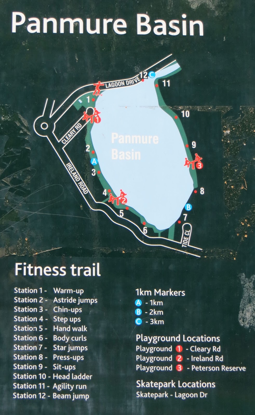
The walkway around the basin can be accessed from several places in the surrounding streets, from the aptly named Lagoon Drive, at the end of Cleary Street, at several places along Ireland Road, and from Peterson and Watene Roads. A broad concrete pathway makes walking easy and the going is mostly level, with one short uphill area on the southern side. Various, rather basic types of fitness equipment have been placed alongside the path for those in need of a greater physical challenge.

Mature trees line the path in many places, providing a pretty display of autumn colour at this time of year, and patches of mangrove forest dot the water around the edges of the basin. The clubrooms of the Panmure Lagoon Sailing Club sit on the north-western shore and the Auckland Society of Engineers on the south-eastern shore – the latter operates a miniature railway on Sunday afternoons, weather permitting. The only blot on the landscape is a series of large electricity pylons plonked right on the southern side of the basin – what planning idiot made that decision?!

Birdlife is plentiful and a delight to watch. As well as the more common birds found in every Auckland garden, I saw perhaps 6 white-faced herons, several ducks, both red-billed and black-backed seagulls, some little pied shags successfully fishing, and a flock of about 40 little pied stilts. According to the signage, white heron have been known to roost in the trees around the basin and there is a well-established colony of pied shags nesting in the trees adjacent to the outlet channel.
A small flock of pied stilts


Left, a white-faced heron and, right, a little pied shag
Panmure Basin is, then, a bird-watchers delight, a peaceful haven amidst the hustle and bustle of a rather industrial suburb, an interesting area for geologists to investigate our explosive past, a place to please the photographer’s eye, has playgrounds to amuse the children, and is an excellent venue for a power-walk or simply a pleasant stroll.