30 May 2014

Turret toppings

As I mentioned in my last blog, about weathervanes, I’ve spent some time recently looking up, which has brought me a new appreciation for the embellishments that have been added to Auckland’s towers and turrets, spires and steeples.

As crosses are to be found on many – though not all -- churches, flagpoles are common on all types of structures, and plain needle-like finials are often found on cupolas (like the examples at Auckland Grammar School, pictured below), I have not, for the most part, included any of them, focussing instead on the more unusual or unique forms of ornamentation.

The plain finial and flag pole on Auckland Grammar School's main building
Most of these turret toppings are purely ornamental, though I suspect some do have a purpose, as lightning rods, diverting the electrical charges of lightning strikes into the ground where they are diffused. Electricity pioneer Benjamin Franklin was the inventor of (in 1749) and a huge advocate for lightning rods, and their efficacy made them extremely popular in the 18th and 19th centuries. This advertisement from the Manawatu Standard, 10 July 1903, shows lightning rods were also popular in New Zealand and how imaginative their designs could, in fact, be.

So, let’s get on with showing you what I’ve been looking at.

Allendale House, corner of Crummer and Ponsonby Roads
On a prominent corner site in Auckland’s inner city suburb of Ponsonby stands Allendale, the large 1890s mansion of George Allen, a saddle and harness maker. This impressive local landmark has been successively a doctor's surgery, Maori girls hostel, boarding house, refuge for alcoholic men and a restaurant, and is now home to the ASB Community Trust, who restored the building after purchasing it in the 1990s.

Allendale is built in a style common for Victorian bay villas, which includes ornate wrought iron work on the verandahs, in the cresting on the roof, and on the turret, as well as the two side roof peaks. These are topped with beautiful examples of the ironworker’s craft – wonderfully sinuous and organic designs.

Allendale House
United Maori Mission Hostel, corner of Hepburn and Smith Streets, Ponsonby
The exact same design as that found on Allendale’s roof can also be found on the roof of a large private dwelling, just a couple of streets away (below, left). Built in the 1890s in the Queen Anne style and sitting on a 1259m2 section, one can only imagine how grand this building must have been when first built. At one time, it functioned as St James’ Presbyterian Manse, then, in the 1940s, it became one of three hostels run by the United Maori Mission, catering for the ‘spiritual, social and material requirements’ of the young Maori people who were then moving in droves from rural New Zealand to the city (Elsdon Craig, ‘Gillies, Heppy and Shelley: The Story of Three Mission Hostels’, Te Ao Hou, no.19, August 1957).

Though it still functions as Te Kainga Aroha, a hostel for young Maori women, this once elegant old house looks rather ramshackle and unloved these days. Luckily, its wonderful roof ornament remains.

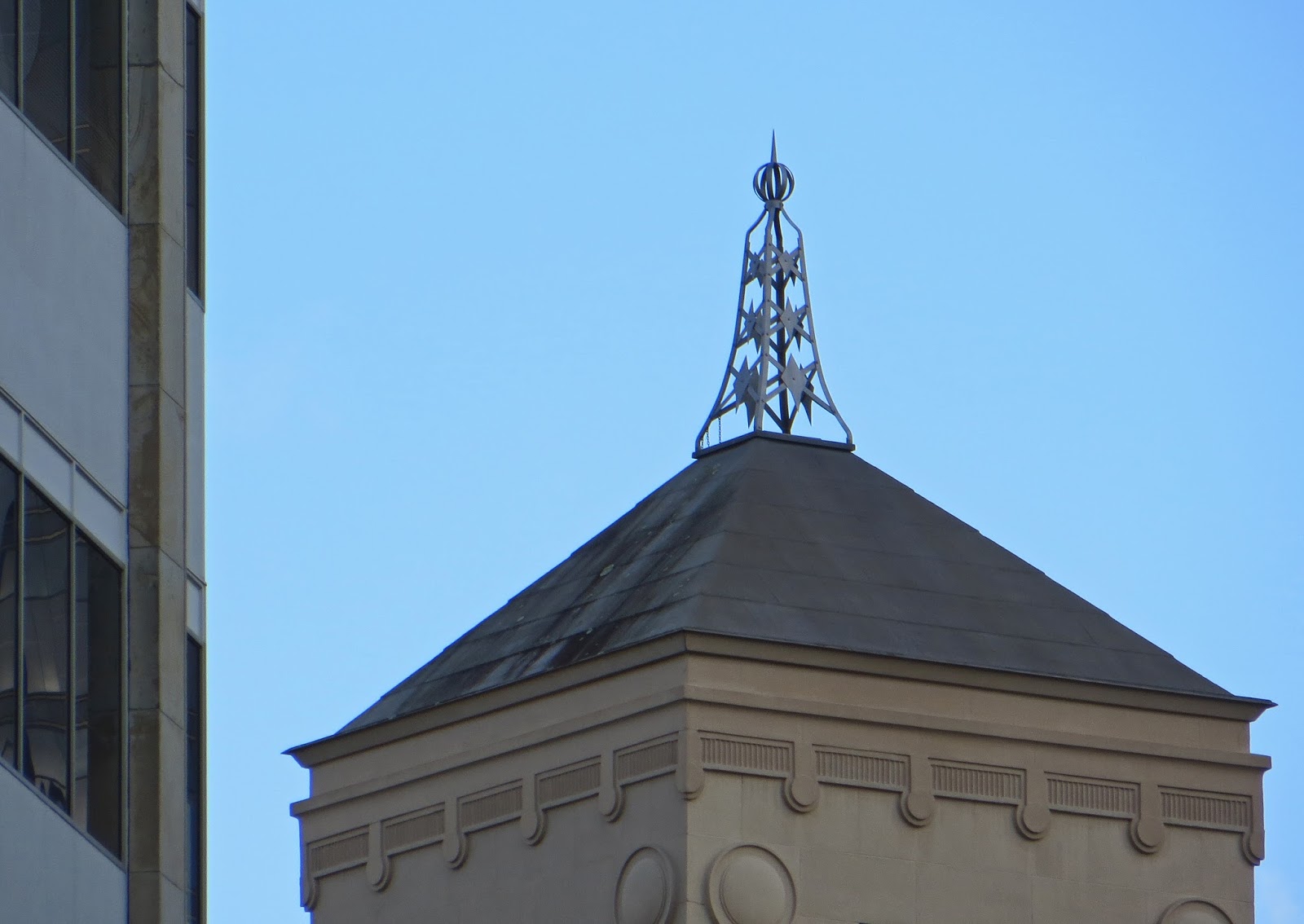
United Maori Mission Hostel (left) and St John's Methodist Church (right)
St John’s Methodist Church, Ponsonby Road, Ponsonby
Though I said above that I would not, for the most part, include churches in this post, some have roof ornaments that deserve a mention. On top of one of the small pinnacles of St John’s Methodist Church, for example, is a fine piece of wrought iron decoration (above, right), not dissimilar to the two mentioned above, though it is more angular, less organic in its lines.

St John’s also has an interesting cross on top of its spire, as you can see from the photo below, left. The church was built in 1882 in the Gothic Revival design by prominent local architect Edward Bartley (who also designed the Royal New Zealand Foundation for the Blind Workshop building with its superb weathervane).

St Stephen’s Presbyterian Church, Jervois Road, Ponsonby
Not far from St John’s is another Gothic Revival-style church, with an interesting embellishment on top of its spire. I suspect this was once a weathervane and Auckland’s occasional wild weather has been responsible for its partial destruction in the 135 years since the church was built. I visited this church during Auckland’s annual Heritage Festival last October so you can read more about this impressive old church in an earlier blog

St John's Methodist (left), St Stephen's in Jervois Rd (centre) and St Stephen's, Symonds St (right)
St Stephen’s Presbyterian Church, Symonds Street, Auckland city
There’s another, even older St Stephen’s Presbyterian Church in the inner city, this one in Symonds Street. Built to last from local basalt stone between 1847 and 1850, this is Auckland’s oldest surviving church and, in keeping with its early Free Church association, it was originally more spartan in design – the Greek-style portico and prominent tower were later additions. Presbyterian churches tend to exclude explicit Christian iconography so there is no cross atop the spire, though it does still have an ornament, a spiky and angular fandangle.

Old Ponsonby fire station, Williamson Avenue, Ponsonby
Heading back to Ponsonby, we find the former Grey Lynn Borough Council Chambers and Volunteer Fire Station building which stands at the Ponsonby Road end of Williamson Avenue. This brick building, dating from 1889, was designed by architect John Mitchell, and resembles many American fire stations of the period. Its bell tower was a practical addition – the bell was rung to alert the volunteer firefighters when fires broke out in the surrounding suburb, though this is actually a replacement tower, reinstated when the building was restored in 1985. It is likely, then, that the adornment on top of its tower is a modern addition but it fits well with the building’s heritage status.

Civic Theatre, Queen Street, Auckland city
Last but not least in this tour around Auckland city’s turret toppings is the magnificent Civic Theatre, which opened in December 1929. Its tower is surmounted by a very ornate embellishment, though I haven’t been able to find out any information about it. The Civic was the last of the great atmospheric theatres to be built in Australasia. Its interior has to be seen to be believed, with its Indian-fantasy-temple-garden foyer, and the starlit night sky and Persian Palace minarets in its auditorium. But that’s a story for another day, another blog …

23 May 2014

Weathervanes, wind vanes and weathercocks

In an effort to improve my photographer’s eye, I often go through periods when, during my daily strolls, I make a point of looking in a particular direction or hunting out certain things. For example, I might spend a whole week looking down (hence my recent fascination with fungi) or seeking out street art or exploring Auckland’s heritage buildings.

During recent days of looking up, I have discovered yet another fascinating aspect of Auckland’s architecture, the embellishments that adorn the city’s turrets and towers, spires and steeples, and this blog on weathervanes is one result – there will be another, about all the other ornamental turret toppings I've found.

Considering they are used to indicate wind direction, it comes as no surprise that weathervanes (also known as wind vanes and weathercocks) are usually found on the highest points of buildings. According to Professor Wiki, the earliest known weathervane (possibly built around 50BC) was a bronze Triton (in Greek mythology, the messenger of the sea) atop the Tower of the Winds in Athens.

Ferry Building weathervane. This wonderful image was taken by John McKillop and is used with his kind permission.
Ferry Building, Quay Street
New Zealand’s weathervanes have no such claims to fame though one of our Auckland weathervanes did literally stop city traffic recently. On 17 April 2014, the remnants of tropical cyclone Ita swept across Auckland, causing huge storm surges to flood waterfront homes and the weathervane on the top of the Ferry Building in Quay Street to sway rather alarmingly. To prevent potential damage to life and limb if it toppled, the street was closed to traffic, and the weathervane has since been removed. Hopefully, it will be repaired and reinstated very soon.


Though their function was purely practical, many weathervanes are themselves beautiful pieces of art and frequently reflect the buildings for which they were designed. The ship design on the Ferry Building is a perfect example and here is another.

Colonial Ammunition Company Shot Tower, Normanby Road, Mt Eden
In 1885, in response to the threat of war with Russia, the Colonial Ammunition Company established New Zealand’s first munitions factory. At that time, their site was far enough away from the built up inner city to be suitable for the manufacture of dangerous goods. Nowadays, the tower is surrounded by commercial buildings and inner-city housing developments. Though activity at the factory increased during the Second World War, when staff numbers rose from 230 to 900, the demand for ammunition steadily decreased and the company closed in 1982.

As this advertisement from the Dominion newspaper (25 November 1916, p.6) shows, the company was very proud of its 140-foot-high state-of-the-art tower, which was used to drop molten metal to make shot. Luckily, the tower and its oh-so-appropriate rifle weathervane (below, left) have survived the wrecking ball and remain a unique part of Mt Eden’s heritage.

Mt Eden weathervanes: at left, on the Colonial Ammunition Company's Shot Tower; at right, on a local building


Mt Eden Village, corner of Essex and Mt Eden Roads
The suburb of Mt Eden is also home to another rather wonderful and very typical weathervane (above, right). The use of a cockerel in a weathervane is where the alternative name ‘weathercock’ originates and is a classic weathervane design, with its origins possibly in Christianity. Apparently, Pope Nicholas issued a decree in the 9th century commanding all churches to display the symbol of a cock on their steeple or dome (the cock is symbolic of Jesus’ prophecy of Peter’s betrayal, Luke 22:34), but there is some evidence that the cockerel appeared in weathervanes before that time and it may simply represent the rooster crowing at daybreak.

According to Auckland City Council’s ‘Mt Eden Heritage Walks’ brochure, the Mt Eden building:

… was erected prior to 1905. Photos show that this side of Mt Eden Road was almost completely unbuilt, rural land in the late 1880s. Designed in a classic Italianate style, this building was a significant addition to the village streetscape, and reinforced this intersection as the hub of the village.

There is nothing to explain the weathervane, unfortunately.

Corner of Carlton Gore Road and George Street, Newmarket
I’ve also found nothing about this next weathervane (on the right in the picture below) of another cockerel and the archetypal compass points. The building is a modern one, currently occupied by the Personalised Plates company, and the weathervane may just be the ornamental addition of an enlightened architect.

Left: on the Royal NZ Foundation for the Blind workshop building; right, on the Personalised Plates building
Royal New Zealand Foundation for the Blind Workshop Building, Newmarket
Not far from Personalised Plates is an older example of a weathervane, on what was the Royal New Zealand Foundation for the Blind workshop building. This building, and the adjacent residential school for the blind, were built in 1909, to provide a sheltered environment for blind people to live, study, learn skills and earn a living.

The design on the weathervane, of a man sitting weaving with cane, appears to reflect the fact that craft industries such as cane basket weaving and furniture making were the principal occupations offered at the Blind Institute until well into the 1970s [Greg Newbold, Quest for Equity: a history of blindness advocacy in New Zealand, Dunmore Press, Palmerston North, 2008].

St Mary’s College Hall, New Street, St Mary's Bay
On the other side of town stands the beautiful old hall of St Mary’s College (above), which has atop its tower a combined wind vane and cross. St Mary’s College is the oldest still-functioning secondary school in New Zealand, founded originally on a different site by the Sisters of Mercy in 1850 but relocated to its present site in Ponsonby in the early 1860s. A wooden chapel dating from that era is still in use but this building, the St Mary’s College Hall, was part of a new school, erected in 1929 at a cost of £36,000, in a picturesque Spanish Mission style on the northern side of the property.

Grey Lynn Library, 474 Great North Road, Grey Lynn
My immediate thought when I saw this turret topping was ‘Quidditch Snitch’. However, though the snitch was first introduced to the game of Quidditch in 1269 by Chief of the Wizards’ Council Barberus Bragge, the folks of early 20th century Auckland were not at all familiar with the world of Harry Potter and his fellow wizards so the similarity must be sheer coincidence.

The Grey Lynn Public Library was designed by architect W. H. Gummer, built of brick in the Georgian style, and opened in December 1924 by then mayor Sir James Gunson. The building continues to be used as a public library and the attached building, on which the snitch sits, as the local community hall. Though the snitch is not your typical weathervane, I have no doubt that its wings were intended to show the direction of the prevailing wind. Sadly, the innovative designer’s name remains a mystery  Rowling, perhaps?

19 May 2014

More Auckland street art: All Fresco 2014

BMD's artwork from All Fresco 2013 - see more on BMD below

Earlier this month I blogged about Auckland’s vibrant street art. I have since found out that a couple of the artworks I featured in that blog were part of street art festival, All Fresco 2014, a wonderful initiative from the K Road Business Association to cultivate the creativity and fringe culture Karangahape Road is famous for.

As I hadn't seen all the works produced by the All Fresco artists, last weekend I made it my mission to find and photograph the others. Here, then, is a further celebration of Auckland’s vibrant street art scene, the All Fresco 2014 festival and the amazing artists who took part.

In my previous blog, Mica Still was the artist in the throes of painting her gigantic work on the back wall of the Lim Chhour Centre in Cross Street. Though now based in Wellington, Mica hails from a small coastal town in Oregon, in the USA, which may explain her love for radiant colours and subjects from the natural world. On the left above is her finished artwork. 

On the right, painted on the same building as Mica’s work, stand a series of giant figures by Benjamin Work. Benjamin is a South-Aucklander of Tongan heritage whose commissions include large-scale public murals like this one, as well as postage stamps and wine packaging. A man of diverse talents!

Owen Dippie’s larger-than-life portraits are astounding, and his work is internationally recognised for its realism and artistic merit. This artwork is on the side of a building in Pitt Street but in Tauranga, where he lives, Owen has been commissioned to produce a series of 15 huge artworks to adorn the walls of his city – three have been finished, the fourth will soon be underway. You can see more on his website.

Central Auckland artist Nigel Roberts hasn’t always painted walls legally but, since 2005, he’s mended his ways and followed the straight-and-narrow, at least in his choice of venue. Roberts says he enjoys painting letters with a brush and developing a 3D effect in his work to make the image pop. That’s his signage, ‘Big Bots are Pops’, on the left in this photo of Beresford Square

The Marilyn Monroe and Audrey Hepburn-lookalike paintings are by Gasp aka Liam Hindsley. He seems to have been painting street art for some years but I haven’t been able to find out much about the man himself.


Founder of the TMD (The Most Dedicated) street art crew Charles Williams combines his talent for bold colour and his love of graffiti with his passion for native New Zealand birds to create stunning artworks like the one above. Wrapping around a corner wall in Poynton Terrace, Charles’s saddleback artwork, entitled Warrior Bird, is simply gorgeous. The multi-coloured circle designs issuing forth from its beak, symbolic of its beautiful song, are by Lady Diva.

Just around the corner from Charles’s big bird is an even bigger artwork, by Misery and Tom Tom. Cascading down the back wall of this building, a series of four kids enjoy some summer fun in the water. Misery is the graffiti street art and fashion label of Australian Tanja Jade Thompson. If you follow my blog, you may remember that she featured in one of my pieces about the 2014 Whittaker’s Big Egg Hunt. Misery often collaborates with Tom Tom on large-scale murals like this one, though Tom Tom is more likely to be found creating smaller artworks – he is a well known Auckland tattooist.


BMD (aka Blake Dunlop) happily admits he likes big walls – and this is one big artwork on one big wall. His four super-size ducks are to be found at the K Road end of Myers Park, and one look at his website will show you that his imagination and his talent are as enormous as the art he produces. He was also responsible for the K Road artwork (shown at top), produced during last year’s All Fresco event.


Last but most definitely not least is the work of Elliot Francis Stewart. He is another member of the TMD group of street artists, and earns a living as an artist and freelance illustrator. His massive contribution to All Fresco 2014 adorns a wall at the K Road end of Ponsonby Road. Apparently, he is amazing to watch working and I just wish I had known the festival was on – I would’ve been there. To make sure I don’t miss out next year, I’m following the event on Facebook and you can too.


14 May 2014

The F word: fungi in Auckland

A combination of the autumnal weather and recent warm rains has produced a proliferation of fungi in the local parks, which has, of course, caught my photographer’s eye and captured my interest. Perhaps, in another life, I was a mycologist.

Fungi are not plants, as they lack the ability to photosynthesise – instead, they get their nutrition either by digesting decaying organic matter or through finding other organisms to act as their hosts.

Did you know that 90 per cent of terrestrial plants – trees, shrubs, and all the rest – form a symbiotic relationship with at least one fungus and some have relationships with hundreds of fungi? According to an article in the latest copy of Forest & Bird magazine (no: 351, February 2014. pp. 46-49), most plants ‘cannot uptake enough soil nutrients, including water, without fungal assistance. All mycorrhizal fungi live either on or in plant roots, most forming sheaths of mycelial threads that effectively increase the surface area of the roots, delivering vital nutrients.’ The fungi tap into the tree roots to get carbohydrates and, in so doing, provide the plants with minerals. It’s a win-win situation.

Of course, all that action happens where we can’t see it – hidden away underground or within a tree. The fungi we commonly see around us are just the fruiting bodies and their purpose is to spread the spores that will enable the fungi to establish new colonies.

You might not realise it but fungi have a huge impact on all of us. On the negative side, they damage our timber through dry rot, they blight our potatoes and rust our maize, and they cause athlete’s foot, ringworm and bronchial problems in humans. But where would we be without the fungi that produce antibiotics like penicillin, or those we use to flavour our cheeses and make our bread rise and, most importantly, those that convert sugar to alcohol!

There are at least a million species of fungi and, though environmentalists battle away for the rights of plants and animals, few people realise that, to ensure the future of our planet, we must also consider our fungi. As Landcare Research scientist Dr Peter Buchanan was recently quoted as saying (in the Forest & Bird magazine cited above) “We need to start talking about flora, fauna and fungi. Fungi is the missing F-word.”

Here are a few of the fungi I have spotted on my daily walks through Auckland’s inner-city parks. Further blogs on the subject are likely!

Scarlet flycap Amanita muscaria
When I first spotted one of these in the Ayr Street Reserve in Parnell, I had a ‘wow’ moment. It was like walking into a fairytale … I half expected fairies and elves to emerge and perform a magical dance amongst the leaf litter. This is, after all, the classic what-every-kid-would-draw-if-you-asked-them mushroom.

The scarlet flycap (also known as the fly agaric or fly amanita) isn’t native to New Zealand but was unintentionally introduced here due to its symbiotic relationship with pine trees, and I’ve since spotted more of these under other pine trees. Its flesh contains psychoactive substances so eating this little beauty would not only result in a hallucinogenic adventure, it would probably kill you. Feast with your eyes only!

Wood-ear jelly Auricularia cornea
Who needs 3-D printers to produce replacement human body parts when you could use a fungus instead? Okay, maybe that’s not a practical solution to gaining a new ear but, you have to agree, they are definitely the right shape, if a little brown and furry.

The wood-ear jelly (its form can be gelatinous, hence the jelly part of its name) is a very common and easily recognisable fungus that grows on standing and fallen dead broadleaf trees, in parks and gardens and forest areas. It can reach up to 100mm across, though its shape becomes more contorted and undulating as it ages. 

A fascinating fact from Ridley’s book (see reference below): ‘It was of considerable economic importance [in New Zealand]… at the end of the nineteenth century and beginning of the twentieth when large quantities were exported to China for food.’ The Maori call this fungus hakeke, and it was a traditional stop-gap food source in lean times.


Turkey-tail porebracket Trametes versicolor
This must be the multi-storey condominium of the fungus world. As the name suggests, bracket fungi resemble shelves or brackets growing from the sides of tree trunks (or condominiums, with large balconies, ranging down the sides of cliffs, if you have an imagination like mine).

The brackets range in size from 20 to 100mm wide and display multi-coloured zones in shades of beige, yellow, orange, brown and even blue, hence the common name of Turkey-tail. It is an extremely variable fungus so no two groupings have the same colour patterns, and it is probably the most common bracket fungus, being found on branches, trunks and logs in all types of forests and plantations.


Giant flamecap Gymnopilus junonius
I had another ‘wow’ moment when I saw my first example of the Giant flamecap, also in the Ayr Street Reserve in Parnell. It was growing off the side of a large fallen tree and its cap was about 200mm across (I photographed it with my hand in the picture to remind me of its enormous size.) These impressive fungi usually grow on broadleaf and coniferous trees, in parks and gardens, but are not normally found in our New Zealand native forests so are not thought to be a native species.

They start out quite small, emerging through fissures in the bark, as you can see from the photo above left. That vibrant orange cap colour seems to intensify as they age, and their flesh and stems vary in colour from yellow-brown to orange-brown.

Revolute inkcap Coprinopsis
From the gigantic and robust to the small and delicate … the Revolute inkcap’s cap ranges from 20 to 40mm in diameter, starting out bell-shaped, then rolling up around the edges as it ages – this all happens very quickly as this little fruiting body lives for just a few hours.

As you can see, it’s a greyish-brown in colour, with thin pale grey flesh. Its gills blacken as it gets older, hence the name inkcap. It can be found in lawns and lawn clippings, in leaf litter and on the forest floor.


Lemon parasol Leucocoprinus birnbaumii
It may not be big enough to protect humans from the rain, but the lemon parasol would work perfectly for the elves and fairies I started this list with. However, as it is mostly associated with the potting mix gardeners use to plant their houseplants, it’s not likely to attract the typical timid fairy.

Tinkerbell might prove the exception and, truth be told, I photographed the vibrant yellow grouping above in the compost-rich soil of a cultivated roadside planting, so there is still hope for a sighting of the little people. The outdoor examples of this fungus are often much paler than those found indoors, as you can see from the examples below.


I used this book (and the internet) to help identify the fungi I’ve found but if you think I’ve misidentified something, please do let me know in the comments section below. Geoff Ridley, A Photographic Guide to Mushrooms and Other Fungi in New Zealand, New Holland, Auckland, 2006 (with photographs by Don Horne)

10 May 2014

Auckland walks: Panmure Basin


As you walk along the banks of this tranquil tidal lagoon today, it’s difficult to imagine the ear-piercing roar and life-threatening explosions that created it at least 18,000 year ago. For the Panmure Basin is a 1.5-kilomtre-wide explosion crater, yet another example of Auckland’s earth-shatteringly violent past.

According to that most excellent book Volcanoes of Auckland, the almost perfectly circular basin was formed by a series of wet eruptions that spewed out a large quantity of the broken-up sandstone through which it erupted, as well as huge clouds of volcanic ash. The sandstone formed the 25-metre-high tuff ring that can still be seen encircling the basin, though most of the rock is now covered by shops and houses.

The basin from nearby Maungarei -- Mt Wellington.
Following the wet eruptions came a period of dry fire-fountaining, though the scoria cone this formed is now buried under mud and silt within the water-filled explosion crater. Water accumulated in the crater after the volcano ceased erupting, initially forming a freshwater lake but, after the north-eastern corner of the tuff ring eroded and sea levels rose at the end of the last Ice Age (about 8000 years ago), sea water entered the crater and Panmure Basin became the tidal lagoon we see today.

Maori people named the basin Te Kopua Kai a Hiku (‘the eating place of the guardian taniwha Moko-ika-hiku-waru’) as they believe a taniwha (a water monster) guards these waters. Over time, this title was shortened to Mokoia, which was the name given to the pa (fortified or defensive settlement or village) situated at the northern entrance to the lagoon in the early 1800s.

After the local Maori people were killed by marauding tribes from the north in 1821, the pa lay abandoned until a European settler, James Hamlin, began to farm the fertile land in the late 1830s. Other settlers followed, including, from 1848, one of the groups of Irish military pensioners (known locally as the Fencibles) who were brought to New Zealand to establish a military base for the defence of the expanding city of Auckland. The name Panmure was bestowed on the growing village by then-Governor Sir George Grey, after Fox Maule, the Lord Panmure, the English War Secretary from 1855 to 1858.

Today, Panmure is an interesting mix of large industrial factories, ethnically diverse and cheap shops and restaurants, and domestic residences, the more upmarket of which can be seen around the southern side the lagoon.

The walkway around the basin can be accessed from several places in the surrounding streets, from the aptly named Lagoon Drive, at the end of Cleary Street, at several places along Ireland Road, and from Peterson and Watene Roads. A broad concrete pathway makes walking easy and the going is mostly level, with one short uphill area on the southern side. Various, rather basic types of fitness equipment have been placed alongside the path for those in need of a greater physical challenge.

Mature trees line the path in many places, providing a pretty display of autumn colour at this time of year, and patches of mangrove forest dot the water around the edges of the basin. The clubrooms of the Panmure Lagoon Sailing Club sit on the north-western shore and the Auckland Society of Engineers on the south-eastern shore – the latter operates a miniature railway on Sunday afternoons, weather permitting. The only blot on the landscape is a series of large electricity pylons plonked right on the southern side of the basin – what planning idiot made that decision?!

Birdlife is plentiful and a delight to watch. As well as the more common birds found in every Auckland garden, I saw perhaps 6 white-faced herons, several ducks, both red-billed and black-backed seagulls, some little pied shags successfully fishing, and a flock of about 40 little pied stilts. According to the signage, white heron have been known to roost in the trees around the basin and there is a well-established colony of pied shags nesting in the trees adjacent to the outlet channel.

A small flock of pied stilts


Left, a white-faced heron and, right, a little pied shag
Panmure Basin is, then, a bird-watchers delight, a peaceful haven amidst the hustle and bustle of a rather industrial suburb, an interesting area for geologists to investigate our explosive past, a place to please the photographer’s eye, has playgrounds to amuse the children, and is an excellent venue for a power-walk or simply a pleasant stroll.


08 May 2014

Auckland walks: Maungarei – Mt Wellington

The 10:10 to Papakura was running late due to “earlier customer issues” – whatever that might mean – so we didn’t depart Auckland’s Britomart train station until 10:20. Not that I cared at all. I hadn’t been on a train journey for a while and, though this was to be a fairly short trip, I was still looking forward to it and happy to sit and people-watch away the extra waiting time.

There are just three stations between Britomart, in central Auckland, and my destination, Panmure – Orakei, Meadowbank and Glen Innes – so, once we got underway, the trip only took 15 minutes. The Panmure train station and transport centre has recently been upgraded so it’s now all shiny glass, escalators and, if you have a transport card, a quick tag off before you exit to the constantly busy Ellerslie-Panmure Highway.

I quickly headed away from its noise and fumes, found the appropriately named Mountain Road and was off on my adventure to explore one more extinct volcano, which, at around 10,000 years old, is the second-youngest of Auckland’s 53 volcanoes.

The view of Mt Wellington from my apartment

This is the cone the European settlers named Mt Wellington, after the Duke of Wellington, but the indigenous Maori people call it Maungarei (which translates as ‘the watchful mountain’ or ‘the mountain of Reipae’). Like most of our volcanoes, this one exhibits much archaeological evidence of its past use by Maori as a fortified village. Its sides were terraced for housing sites and there are numerous pits where food was stored.

Maungarei may be a relative youngster but it’s not small – according to the book Volcanoes of Auckland, from base to crest, Maungarei’s cone is 100 metres tall, making it the tallest of Auckland’s volcanoes and the trig, at the highest point on the crater rim, is 162 metres above sea level. Its size means it’s a prominent landmark, easily seen from much of the city, and it sits exactly in the centre of my view as I look out my central-city apartment window. Since I moved here last August, that big mountain has been enticing me to visit.

There are no walking tracks up the mountain, just a narrow single-track road that goes up one side and down the other. It’s quite a steep walk but the views get increasingly more impressive as you ascend, providing a good excuse to stop and catch your breath, and to take photographs. Unfortunately, the immediate surroundings are filled with the grey expanses of factory buildings and large stacks of containers but, if you overlook those, you get fine views of the Panmure Basin, the Tamaki River and the inner Hauraki Gulf.

At right, Panmure township and Panmure Basin, with the Tamaki River running from the right background to the left.

Looking across the Tamaki River towards Farm Cove and Half Moon Bay
About half way up the mountain, there’s a flat area where one of its three fire-fountaining craters was filled with a concrete water reservoir back in 1960. There is a car park, as well as some picnic tables and benches. From there, you can follow a scoria-covered track up and around the rim of the volcano. This scoria proved slippery in places so I stuck to the grass at its edges. There are also tracks through the grass, which you can follow to explore the old pits and terraces and to descend the 60 metres into the southern and western craters.


Foregound, the southern and western craters, with the concrete reservoir in the northern crater in the background

As there are hardly any trees on the upper parts of the mountain, the rim walk provides spectacular 360-degree views in all directions, to the city skyscrapers, Waitemata Harbour and its islands in the north and east, to the Bombay Hills in the south, and over the Manukau Harbour in the west. Next to the trig at the highest point, there's a rather ugly, short concrete column that is topped with an engraved metal plate which points out the various landmarks to be seen. There are a couple of park benches on the northern terraces but, unfortunately, no signage to inform visitors about their surroundings.


The skyscrapers of the central city can just be seen on the horizon at right.
Still, I delighted in the views, the fresh air and the exercise. And now when I look out my window at Maungarei, I know more exactly what I am looking at and can remember the pleasant couple of hours I spent exploring there.

Another view from my apartment. I love how the early morning clouds and mist are flowing over the mountain top.