26 November 2021

National Gutters Day : Penarth

Today is National Gutters Day 2021, which has motivated me finally to write another post for this blog, to share these photos of some gutters in the Victorian seaside town of Penarth, in south Wales.


 Built originally between 1889 and 1891, then rebuilt in 1926 after a devastating fire, All Saints Church sits in a tree-filled green space in central Penarth. As you see from the photo above, its gutters are not dated so I’m not sure if they date from the late 19th century or from the more recent reconstruction.


Here’s another dating mystery. This gutter hopper adorns the Mortuary Chapel at Penarth Cemetery. The building itself does not appear to be listed, and a search of the Welsh newspaper archives failed to turn up any information on the building of the chapel, though I did discover that the first burial in the cemetery was in 1903. I’ve also not turned up any information on the Glaswegian foundry that made this item.
 

As you can see, this gutter on the old building at Stanwell School has not been well maintained so it’s difficult to make out its surface decoration. An article in the Weekly Mail of 23 January 1897 reported on the recent opening of Penarth Intermediate School which, though it has since changed its name and been much expanded, continues to serve the education needs of local community in the 21st century.
 

Headland School was originally the Penarth Hotel, built in 1868 by the Taff Vale Railway Company, when Penarth docks handled a lot of the exports of coal pouring down from the valley of the River Taff. The building was repurposed after World War One, when it was purchased by the widow of a war casualty, one Major J.A. Gibbs. In the Major’s memory, his wife gifted the building to the authorities who ran the National Children’s Homes, who used it from July 1921 as a nautical training school.


10 March 2021

Doors : Penarth knockers

During this pandemic, while we’ve been under local area restrictions, I’ve used some of my daily exercise walks to get to know my town a little better. When I was checking out local houses last December for my post on Christmas wreaths and then again in January for the street numbers (House numbers, 1 to 10 and House numbers, 11 to 20), I couldn’t help admiring the knockers some house owners have adorning their front doors.


Some are old but still stylish – lions have long been a favourite of mine ...


Many are very similar to each other, the same overall size, shape and design, and were perhaps attached when the houses were first built ...


Others are simple geometric shapes, functional, practical ...


The best to my eyes – the ones I would love to have on my front door, if I had one – are the more creative designs, perhaps reflecting the house’s location – the anchor a nod to the adjacent marina, or a personal interest – the nature-lovers who chose the fox, the bee and that stunning snail.


With these delightful door knockers, the home owners have added a touch of their own personality and more than a little panache to their front doors. And what an impressive statement they make to the world.
28 February 2021

It’s a sign: Penarth

I haven’t published a blog about signs for a while so, without further ado, here are some I’ve seen on my local exercise walks.

Dogs must be led
To mark the passing of 117 years since its opening, I blogged about Penarth’s Alexandra Park back in June 2019. This sign, mandating that ‘dogs must be led’, can be found on one of the park’s main entrance gates. I’m not sure if the sign is as old as the park or, indeed, what dog control bylaws were in place in 1902. Regardless of the instruction, or the current bylaws, almost every dog owner ignores this sign and allows their dog (or dogs) to roam at will. This may surprise readers in other countries, as it also surprised me when I first moved to Britain from New Zealand, where dog control laws are much stricter and more tightly policed.     

Do not cut bait on the decking
I also blogged about the opening of Penarth’s pier on its anniversary, this time the 124th anniversary (Penarth: the opening of the pier, April 2019), though this is, of course, a much more recent sign. Fishing off the pier is actually banned during the summer months of June, July and August, and, at other times, is restricted to specified areas but, even there, it seems the anglers have been damaging the wooden boards with their knife work, hence the need for this sign. It’s not one I’ve seen anywhere else.

Dangerous cliffs. Keep away
I rather like the contrast between these new and old signs, warning those who dare to walk along the shore beneath the Penarth Head cliffs, of the danger of falling rocks. Unfortunately, despite plenty of visual evidence of recent rock falls and even, in places, the sound of constantly falling pebbles, many people ignore these signs and walk far closer to the bottom of the cliffs than is healthy.

As you can see, the old sign also warns the unwary of being caught by the high tides. This should also not be ignored, as the Bristol Channel has the second highest tidal range in the world, at between 12 and 14 metres, and there is literally nowhere to go if you get caught below these cliffs when the tide is at its highest extent. 

I find it particularly interesting that, while both signs give their warnings in English and Welsh, the old sign also repeats the message in French. Were the majority of tourists visiting Penarth in times past of French origin, or were the locals expecting an invasion?


Hedgehog crossing area
I definitely approve of signs like this, warning vehicle users to be aware of animals, of all kinds, crossing roads, though in this case the sign seems rather superfluous. 

It’s at the blocked end of a little-used lane, where at most two residents’ cars would pass. Also, the gate to which it’s attached doesn’t have a hole at the bottom for hedgehogs to pass under and into the garden beyond. 

Perhaps the residents just want to show their general appreciation of and support for any hedgehogs that happen to be passing. Can hedgehogs read, I wonder?

21 February 2021

Cardiff art: Three Ellipses

If you’ve ever walked over the Cardiff Bay Barrage, you might have noticed splotches of yellow paint, seemingly splattered randomly around the lock area, under your feet, on parts of railings and halves of benches, partially covering life buoys, swiped across fixtures and fittings. It’s really quite bizarre!

As well as being the colour of sunshine and warmth, yellow is also a colour of caution, warning of the need to be careful, to take safety precautions, so painting surfaces yellow can indicate trip hazards, concealed danger, potential obstacles. But that doesn’t seem to be the case here.

The colour yellow is also known for its high visibility, which is why it’s often used on road safety signage, on ambulances, police vehicles and fire engines. The colour can be seen, the painted shapes recognised from a distance. Now maybe we’re getting closer to an explanation of the Barrage blotches?

There’s only one way to solve this mystery, and that’s to stand in one specific spot on the Barrage near the locks and look seaward. Only then can you see, in its entirety, the amazing artwork that is Three Eclipses for Three Locks.

The brainchild of Swiss artist, Felice Varini, who specialises in optical illusional artworks, this piece was painted on the Barrage in March 2007, by a team that included professional mountain climbers to paint the less accessible spaces. I love it for the way it challenges the mind of the viewer to figure out and complete the fragmented puzzle but I do think it’s time the Cardiff Harbour Authority repainted it. It would be a great shame, and a huge waste of the initial cost of £25,000, if this piece was allowed to fade into obscurity.

14 February 2021

Llandough: inside St Dochdwy’s

I’ve blogged before about St Dochdwy’s Church in Llandough, the exterior of the church (Llandough: St Dochdwy’s Church, 3 April 2020) and, a few days later, the magnificent Irbic cross in the church yard (Llandough: the Irbic cross). At that stage, I hadn’t been inside the church but, recently, completely by chance, I had the opportunity to have a brief look inside and to grab some quick photos.

Completed in 1866, by Penarth builder David Jones to a design by Bristol architect Samuel Charles Fripp, the current church incorporates elements of the previous church on this site, in particular ‘the original Norman Chancel arch, which now links the south aisle to the bell tower’ (as per the St Dochdwy’s website).   

 An article from the Cardiff Times, 13 July 1866, reports on the opening of this new church:

RE-OPENING OF LLANDOUGH NEW CHURCH.

The consecration of the church at Llandough, near this town, which has recently been rebuilt and enlarged, took place yesterday (Thursday). A large and highly respectable congregation was present, and it was with difficulty that sufficient accommodation could be provided for the worshippers. The new church was built in consequence of the old one being too small for the requirements of the increasing population, and the rebuilding was principally brought about through the exertions of the rector, the Rev. H. H. K. Rickards, and Mr. R. E. Spencer. The new edifice has been erected on the east side of the old church. The design belongs to the decorative period of Gothic architecture. Both externally and internally it has a good effect. The chancel arch of the old church has been restored and used in the new building. The church is built of Leckwith stone, lined with bricks, and freestone is used for the windows, doorways, and pillars. There is a conspicuous tower, and the church being on elevated ground, it is visible from a great distance. The principal entrance is to the west, and immediately opposite the altar, over which is a large stained memorial window, to the late Rev. James Evans and his son the Rev. Charles Evans. Two fine freestone pillars on either side support the aisle arches and open stained wood roof. The side windows are also ornamented with stained glass. The pews are of stained wood and without doors. In the course of time, should further accommodation be required, this can be provided by taking down the west wall. The cost of the re-building is £2,600, all of which has been subscribed with the exception of £500. Mr. Fripp, of Bristol, was the architect, and Mr. David Jones, of Penarth, the builder ...

When I entered the church, my eye was immediately drawn to the design of its brickwork, a stunning example of ‘the decorative period of Gothic architecture’ referred to in the newspaper report. This polychromatic brickwork is very similar to that inside Penarth’s St Augustine’s Church, designed by renowned architect William Butterfield, though it is not believed to be Butterfield’s work.   

The church also features some beautiful stained glass windows, including a 5-light traceried window in the west front wall, though I didn’t have time to examine the many windows closely. And I’m sure there are other features that will repay a second visit, when the current pandemic restrictions allow that to happen.


07 February 2021

Cardiff art : Cader Idris

I’ve sat and eaten my lunch on it, I’ve sheltered in its lee from driving wind and rain, but it was only recently that I finally found out more about this hulking artwork.

This is Cader Idris, a sculpture that was first sited in the large square outside Cardiff Central Station in 1999 but was moved ten years later to Cardiff Bay Wetlands Reserve. As the English section of the inscription on the plaque adjacent to the sculpture reads:

The mountains, lakes and valleys of Wales have inspired this sculpture, and in particular Cader Idris, in Snowdonia.

Naturally, many Welsh poets have found similar inspiration and it is those verses which reflect this subject that have been chosen here. All of them are by Welsh poets and in their original language, be it Welsh or English. The englyn is a unique verse form characterised by the particular setting of the lines. Four englynion are included in this selection, and the one by Rhys Dafis was especially composed for this sculpture.

At this point I was somewhat confused by the references to poetry inscriptions as I hadn’t noticed any – more on that below.

Cader Idris was created by William Pye, a London-born artist who studied sculpture at the Royal College of Art from 1961 to 1965, and has since taught and exhibited his work in museums and art galleries around the world. Although the design and dimensions of the Cardiff work were very much influenced by the Welsh mountains, Pye writes that many of his other creations have been inspired ‘by the extraordinary qualities of water and [he is] fascinated by the natural laws of hydrostatics and how these can be manipulated.’ Some of you may have seen the magnificent font he created for Salisbury Cathedral in 2008, or perhaps you’ve seen the shimmering Slipstream as you’ve passed through Gatwick Airport’s north terminal, or you may have encountered Chalice, within the precincts of 123 Buckingham Palace Road in London. Pye is a prolific creator and the list of his works is a long one.   

Returning to Cader Idris, Pye writes that his inspiration came partly from a painting of the mountain by Richard Wilson (1714-82), which Pye says ‘has been a particular favourite of mine since my schooldays and holidays in Wales. This painting has inspired me to create a number of sculptures, the Cader Idris Series.’      

Cader Idris is 13 feet (4 metres) tall and made from a combination of Woodkirk sandstone and Welsh blue pennant slate, which the sculptor explains as follows on his website: ‘Water is inferred at the centre of the structure where the darker pennant stone represents a cwm (circular lake) at the foot of an escarpment.’ Pye goes on: ‘The bronze element of the sculpture suggests a rock outcrop and is set with verses in Welsh and English, all by Welsh poets.’

Now I was even more confused, as it seems I had missed both poetry inscriptions and the ‘bronze element’, so I returned to the sculpture for another look. Still nothing. Then, after much searching, I discovered that the artwork was altered when it was moved. When it was located in central Cardiff, it had a small step built into one side and, more importantly, there was an additional rectangular piece adjacent to the stone ‘mountain’, a piece that was made of bronze and that had the poetry, the englyns, inscribed on one side. (There’s a photo of the original artwork on the VADS website here.)   

I haven’t been able to find any explanation for why the artwork was altered. Nor have I discovered what happened to the ‘bronze element’. To my eye, though Cader Idris still has a significant visual impact in its new setting, the piece has been diminished and much of its meaning obscured by the loss of the 'outcrop' and its poetry, and that seems a great shame.

04 February 2021

Under my feet : Mt Stuart Ship Repairing Yard marker

Under my feet today is a marker I walked over many times before, after deciding to pay more attention to what was ‘under my feet’, I stopped to read what it said and take photographs.

The plaque reads, in English and Welsh: ‘The granite setts show the line of the dockwall and the entrance to the former Mount Stuart Ship Repairing Yard : Mae’r sets ithfaen yn dangos llinell mur y doc a’r fynedfa i hen Iard Trwsio Llongau Mount Stuart’.

Cardiff had long been a port but it wasn’t until the early 19th century that it grew dramatically when the coal and iron trades increased rapidly to service the needs of the industrial revolution. Huge docks were constructed, starting with the Bute West Dock in 1839 and running right through to the Queen Alexandra Dock in 1907. And, though Cardiff never developed into an important shipbuilding location, it did become a major hub for ship repairing companies. 

In 1843, the Batchelor brothers, John and Sidney, moved from Newport to Cardiff to set up a ship repair yard. From their initial location on the banks of the River Taff, they moved six years later to the West Dock and then, several years after that, they opened the Mount Stuart Graving Dock. After the Batchelors’ operation went into liquidation in 1873, their business was eventually sold to Sir John Gunn, and the company became the Mount Stuart Ship Building, Graving Docks, and Engineering Company.

The 1882 sketch of the Mountstuart Dry Dock and Engineering Co’s Works, above left, is from William Turner’s publication The Port of Cardiff *. The photograph, above right, shows the three docks in use at a much later date, probably sometime in the mid 1900s (the image is not dated) **. Advertisements for the Mount Stuart company, dating from 1891-92 and 1895-6, can be seen on the Grace’s Guide to British Industrial History website.

 As you can see from the photograph above right, there are three docks, ranging in length from 430 feet (131 metres) to 543 feet (165 metres): Coflein, the online database for the National Monuments Record of Wales, gives the exact measurements, and details of how these changed over time.    

After the Cardiff Bay Barrage was completed in 2001 and the bay changed from a tidal harbour to a freshwater lake, the three Mount Stuart docks were flooded. Two remain empty but dock number 3 contains pontoons, used to moor small boats. The photographs below show dock number one as it currently looks.

Image from Wikimedia Commons: Dated 1882. Accession no: British Library HMNTS 10369.cc.8. Image extracted from page 110 of The Port of Cardiff, by TURNER, William - Author of Custom Houses, an out-of-copyright book. Original held and digitised by the British Library. https://upload.wikimedia.org/wikipedia/commons/1/11/TURNER%281882%29_MOUNTSTUART_Dry_Dock_and_Engineering_Co%C2%B4s._Work.jpg

** Image from Wikimedia Commons:  https://upload.wikimedia.org/wikipedia/commons/4/4d/Mount_Stuart_dry_docks_%28451103725%29.jpg


Note re the term ‘graving’: I was not familiar with this word when I started researching the Mount Stuart plaque so was fascinated to learn its meaning. If you’re interested, there’s a short explanation on the Wikimapia entry for Mount Stuart Graving Dock 3.   

31 January 2021

House numbers, 11 to 20

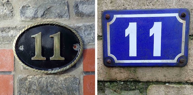
In my previous blog, House numbers, 1 to 10, I covered subjects like the design, layout, and materials used to create the numbers people have attached to their houses. This time I want to look at the back story of house numbering, while also displaying more of the attractive numbers I’ve found during my local exercise walks.

As is surely obvious, giving a house a number and a street a name makes it much easier to locate that house, yet house numbering does not exist everywhere in our world. In some places, houses are identified by name rather than number; in other places, they have both name and street number; and, where numbers of residents are low, neither system exists.


To add to the potential for confusion, even where numbering systems are used, there are variations in those systems. Some streets may have odd-numbered houses on one side of the street and even numbers on the opposite side but there are also places where houses were only planned for one side of a street and so those numbers are consecutive. When the other side of the street was subsequently built on, the numbers were not changed to an odds-and-evens system – they simply continued in consecutive order along the other side of the street.

As for the history of house numbering, Wikipedia has a seemingly well-researched article that gives 1512 as the earliest known numbering system, which was in a suburb of Paris, France, but it was until the 18th century that official numbering systems were introduced in various locations across Europe.  

In Britain, according to a post on The British Postal Museum and Archive blog, the first known instance of house numbering dates from around 1708, when Edward Hatton’s two-volume publication A New View of London, or An Ample Account of that City in Eight Sections stated that the houses in Prescott Street, Goodman’s Fields were identified by number rather than name. That seems to have been a local idiosyncrasy, however, and it wasn’t until 1766 that two Acts of Parliament were passed that included house numbering, though only in two very specific locations, the Borough of Southwark and the City of London (Act 6 Geo III c24 and Act 6 Geo III c26, both dated 1765 but not enacted until the following year – see comments by John Copeland and others on the British Postal Museum blog referenced above). And even that legislation may not have made numbering compulsory – an article on the maps.thehunthouse.com website questions the wording of the legislation: the use of the words ‘shall and may’ rather than ‘must’ may indicate that usage of the numbering system was optional.

Although other towns and cities no doubt recognised the advantages of, and adopted, similar numbering systems in the latter part of the 18th century, it wasn’t until 1855 that the Metropolitan Management Act decreed a more comprehensive and all-encompassing system of controlling and regulating the names of streets and the numbers of houses.
 

No doubt it took some time to instigate the changes this Act stipulated, time to design and manufacture street and house signage, to allocate and map logical numbers, to inform everyone of the new labels and encourage their use. But, as the new numbering systems came into effect, I’m sure postal delivery workers collectively heaved a massive sigh of relief as their task of finding the correct locations for their deliveries was progressively made much more straight forward.