Showing posts with label volcano. Show all posts

07 June 2014

Auckland walks: Mt Victoria and North Head

Leaving on the ferry
One of the best things about having so many volcanic cones dotted around Auckland is the panoramic views you get from the top of them and, as most are very accessible for walkers, you can easily combine exercise and sightseeing by a walk to the top of one … or, in this case, two.

As I live in the central city, access to these two volcanoes, Mt Victoria and North Head, is via a quick 10-minute ferry ride across the Waitemata harbour to Devonport. This is a pretty little seaside suburb, with architecturally significant colonial-era houses, craft shops and galleries stocked with fine examples of local artistry, a range of outdoor cafes with offerings to satisfy the most demanding taste buds, as well as beaches and parks where you can stroll off the calories after you indulge!

My map – and this blog post – focus on the walk I did last week but Devonport is worth exploring further. In fact, the place has so much to offer there are two websites to show visitors what to see and do, and where to stay and eat.

Devonport and Mt Victoria

From the ferry, the direct route to Mt Victoria takes you up the main street, Victoria Road. With extreme difficulty, I resisted the temptation to browse the shops and galleries (you can always return to these at the end of your walk!) and focused on the hill. At the entrance to the reserve, across Kerr Road, there’s a sign showing the road and pathways but, basically, you just follow the road -- a steep-ish climb to the 87-metre summit, but with plenty of opportunities to stop for photos, it’s easily managed.

Named after Queen Victoria, this volcanic mount was formed by the fire-fountaining of frothy scoria from a central crater, which was later breached on the south side by a lava flow that extends towards the Devonport foreshore. When the tide’s out, you can clearly see the remains of this lava flow on the beach between Devonport wharf and Torpedo Bay, and its rock pools are fun to explore, though sturdy footwear is required.

Looking from Mt Victoria to North Head and Torpedo Bay
This mountain is not just a scenic reserve. It was used as a pa (fort and village) by early Maori and, due to its height and prominent position, the signal station for the Port of Auckland was sited on top in 1841. Much updated and now fully automated, it still functions today, and the old signalman’s house has become the Michael King Writers’ Centre, supporting the development of high quality New Zealand literature. The mount was also the site of 64-pounder muzzle-loading guns when, in 1885, Aucklanders feared an invasion from Russia, and still houses an 8-inch disappearing gun that dates from 1899. The northern side of the crater contains a water reservoir, the vents from which have been painted to resemble artificial mushrooms growing in the grass.

Looking from Mt Victoria back towards the central city
Once I’d checked out the historical sites, soaked in the views and taken a hundred photos, I headed down a track on the eastern side of the mountain, emerging on to Church Street via Flagstaff Lane. I turned left and continued along Church Street a short distance until the entrance to Cambria Reserve appeared across the street. This pretty park was once home to a 30-metre-high volcanic cone but one hundred years of quarrying away its scoria and rock have almost flattened the land, and landscaping by the local council has produced yet another green and tree-filled space for a pleasant stroll. I did a quick circuit and emerged on the eastern side, where the old, relocated Presbyterian Church now serves a new purpose as the Devonport Museum. It was closed on the day I visited but I’m sure its collections of memorabilia and photographs would be worth a visit.

Looking from Mt Victoria across the Mt Cambria Reserve and Cheltenham Beach towards Rangitoto Island
You could walk all the way up Vauxhall Road and access Cheltenham Beach from the northern end but I always choose the greener route if I can, so I strolled across the grounds of the North Shore Rugby Club to Tui Street, then turned left into Tainui Road and took the next right (Matai Road), which took me straight to the beach.

Looking north along Cheltenham Beach from North Head
With its golden sands and a grand view out to Rangitoto IslandCheltenham Beach is a favourite spot for walkers and swimmers alike. Dogs chased sticks, energetic youngsters jumped to catch Frisbees, families picnicked, and seagulls squabbled over fishing rights in the shallow water – it was an idyllic sunny scene and I lingered awhile to enjoy it all, soak up some sunshine and dry my feet after a paddle. Then, it was off southwards along the beach to my next volcano, the 50,000-year-old North Head, the eroded remains of a scoria cone overlying a small tuff cone.

Just like Mt Victoria, North Head’s strategic location at the entrance to the inner Waitemata Harbour has led to its use as a defensive fortification, with more muzzle-loading guns placed here in 1885 and three disappearing guns in 1886. Prior to the First World War, prisoners were used to excavate tunnels linking the gun emplacements and their service facilities, and exploring these is a fun activity for young and old alike. Fearing invasion by the Japanese, North Head’s defence capability was further developed during the Second World War and the fort served as the Regimental Headquarters for the entire Hauraki Gulf defence system.

These days, North Head is part of the Hauraki Gulf Maritime Park, and the Department of Conservation manages the heritage buildings and defence facilities and artefacts still found there. Their website contains excellent information and a guided walk pdf so interested visitors can learn more about these aspects of Auckland’s history. 

North Head from Torpedo Bay, with the Navy Museum and cafe at bottom right


I wandered the paths, at sea level and around the top of the cone, once again enjoying the panoramic views and taking lots of photographs, before heading down to Torpedo Bay, its excellent Navy Museum and café for some well-earned lunch. Afterwards, as I strolled the seashore back towards the ferry, I was treated to the antics of a plethora of birds: herons and cormorants, kingfishers, oystercatchers and gulls. Sitting on the ferry back to the city, I knew I had only scratched the surface of all Devonport has to offer and vowed to return again soon to explore further.

Information about the volcanoes listed here came from Bruce Hayward’s excellent book Volcanoes of Auckland: the essential guide, Auckland University Press, 2011. 

08 May 2014

Auckland walks: Maungarei – Mt Wellington

The 10:10 to Papakura was running late due to “earlier customer issues” – whatever that might mean – so we didn’t depart Auckland’s Britomart train station until 10:20. Not that I cared at all. I hadn’t been on a train journey for a while and, though this was to be a fairly short trip, I was still looking forward to it and happy to sit and people-watch away the extra waiting time.

There are just three stations between Britomart, in central Auckland, and my destination, Panmure – Orakei, Meadowbank and Glen Innes – so, once we got underway, the trip only took 15 minutes. The Panmure train station and transport centre has recently been upgraded so it’s now all shiny glass, escalators and, if you have a transport card, a quick tag off before you exit to the constantly busy Ellerslie-Panmure Highway.

I quickly headed away from its noise and fumes, found the appropriately named Mountain Road and was off on my adventure to explore one more extinct volcano, which, at around 10,000 years old, is the second-youngest of Auckland’s 53 volcanoes.

The view of Mt Wellington from my apartment

This is the cone the European settlers named Mt Wellington, after the Duke of Wellington, but the indigenous Maori people call it Maungarei (which translates as ‘the watchful mountain’ or ‘the mountain of Reipae’). Like most of our volcanoes, this one exhibits much archaeological evidence of its past use by Maori as a fortified village. Its sides were terraced for housing sites and there are numerous pits where food was stored.

Maungarei may be a relative youngster but it’s not small – according to the book Volcanoes of Auckland, from base to crest, Maungarei’s cone is 100 metres tall, making it the tallest of Auckland’s volcanoes and the trig, at the highest point on the crater rim, is 162 metres above sea level. Its size means it’s a prominent landmark, easily seen from much of the city, and it sits exactly in the centre of my view as I look out my central-city apartment window. Since I moved here last August, that big mountain has been enticing me to visit.

There are no walking tracks up the mountain, just a narrow single-track road that goes up one side and down the other. It’s quite a steep walk but the views get increasingly more impressive as you ascend, providing a good excuse to stop and catch your breath, and to take photographs. Unfortunately, the immediate surroundings are filled with the grey expanses of factory buildings and large stacks of containers but, if you overlook those, you get fine views of the Panmure Basin, the Tamaki River and the inner Hauraki Gulf.

At right, Panmure township and Panmure Basin, with the Tamaki River running from the right background to the left.

Looking across the Tamaki River towards Farm Cove and Half Moon Bay
About half way up the mountain, there’s a flat area where one of its three fire-fountaining craters was filled with a concrete water reservoir back in 1960. There is a car park, as well as some picnic tables and benches. From there, you can follow a scoria-covered track up and around the rim of the volcano. This scoria proved slippery in places so I stuck to the grass at its edges. There are also tracks through the grass, which you can follow to explore the old pits and terraces and to descend the 60 metres into the southern and western craters.


Foregound, the southern and western craters, with the concrete reservoir in the northern crater in the background

As there are hardly any trees on the upper parts of the mountain, the rim walk provides spectacular 360-degree views in all directions, to the city skyscrapers, Waitemata Harbour and its islands in the north and east, to the Bombay Hills in the south, and over the Manukau Harbour in the west. Next to the trig at the highest point, there's a rather ugly, short concrete column that is topped with an engraved metal plate which points out the various landmarks to be seen. There are a couple of park benches on the northern terraces but, unfortunately, no signage to inform visitors about their surroundings.


The skyscrapers of the central city can just be seen on the horizon at right.
Still, I delighted in the views, the fresh air and the exercise. And now when I look out my window at Maungarei, I know more exactly what I am looking at and can remember the pleasant couple of hours I spent exploring there.

Another view from my apartment. I love how the early morning clouds and mist are flowing over the mountain top.

10 January 2014

Day trip to Rangitoto

We caught the 9.15 ferry from downtown Auckland, armed with sunscreen and sunhats, drinks and lunch (there are no shops on the island, so you need to come prepared), sturdy walking shoes (or, in my case, sandals) and cameras. And the camera came out early as the huge cruise ship Celebrity Solstice was docked at Princess Wharf, the clouds were very pretty and the sea an incredible blue.


The direct ferry ride only takes about 25 minutes so Rangitoto is the perfect distance from the city for a family day out and the perfect destination for those interested in the geology, those wanting to explore the many hiking tracks or check out the native wildlife, or those who simply want to enjoy a day away from the hustle and bustle of city life.


Rangitoto Island is the youngest and largest of the Auckland region’s 50-odd volcanoes, having formed by eruption about 600 years ago. Rest assured, it is now dormant (!), but it still provides a fascinating glimpse into the geology of a volcano. For those interested in such things, the hiking tracks give up close and personal glimpses of old lava flows, large heaps of scoria and, at the top, the summit crater.


The island became a Public Domain way back in 1890, with the first wharf and track to the summit being built in 1897. Prisoners from Auckland’s Mt Eden prison were used to build some of the roads in the 1920s and 30s and, nowadays, those roads and the well-maintained series of walking tracks mean that visitors can choose to tackle the summit path for awesome views of Auckland city and the Hauraki Gulf, or simply spend the whole day exploring this fascinating island.


The trek to the summit takes about an hour – it is family friendly (we saw one family wheeling and carrying a baby buggy all the way to the top – just a little mad!) but, be warned, the final part of the ascent is quite steep, though easy enough to negotiate. Those who are less mobile can pay to join the Rangitoto Volcanic Explorer tour, which takes you round the island seated on a 4WD road-train, of open-air carriages pulled behind tractors, though you still have to walk up a long series of 300 wooden boardwalk steps to get to the summit.


Of course, we joined the walkers heading for the summit – you’ve gotta do it at least once! The walk takes you through lava fields and native forest and, as you climb, there are frequent opportunities to stop for photographs of the ever-more-awesome views – the perfect excuse to catch your breath and take a drink. The 360-degree views from the summit are spectacular, ranging from the rugged horizons of the Waitakere Ranges in the west across the central city and the beautiful islands of the Hauraki Gulf to the Hunua Ranges in the south. 


We came back down the alternative boardwalk route, then made our way along the unsealed road to the Rangitoto Wharf. It was a long walk but we were entertained by tuis warbling, by more fantails than I’ve ever seen in one day before fluttering back and forth across our path, and by wrens flitting in and out of the bushes. On the summit, I also saw my very first saddleback – sadly, it was too quick for a photo.

Rangitoto is home to the world’s largest pohutukawa forest, as well as trees that are a strange hybrid of pohutukawa and northern rata. The lava outcrops seem inhospitable but, over time, they are gradually colonised by lichen and ferns, followed by shrubs and bushes, then eventually the trees. The island is home to more than 200 species of native plant, including 40 different types of fern and several species of orchid.


Back down at the wharf, we tucked hungrily into our well-earned lunch and rested a while, before taking the track west along the coastline. These days no one lives permanently on the island but, in the early 20th century, a small community of people lived in the baches (a New Zealand word for a simple holiday house) that line parts of the shoreline. In the 1970s and 80s, a large number of the old baches were demolished but, these days, those that remain are registered as Historic Areas with the New Zealand Historic Conservation Trust, and many are still used as holiday homes by the descendants of the original owners.


The Trust has done a great job of researching the families who have lived in the bach communities over the years, collecting over 50 oral histories and more than 300 photographs. At the empty sites of those baches that were knocked down there are signboards telling the histories of the places and their people. They provide wonderful glimpses of Kiwi history.

The bach nearest Rangitoto Wharf, Bach 38, has been restored to its original condition, complete with all the fixtures and fittings you would have found in a bach dating from the '30s or '40s. The bach was built in 1927 for Walter Pooley, the first caretaker on the island and then-owner of the shop and tearooms (since closed).


We relaxed some more on the benches of the information kiosk near the wharf, before joining the hordes of tourists boarding the ferry for the breezy voyage back in to the city. We were weary but content, having enjoyed the strenuous exercise, the refreshing sea air, and the entertaining birdlife. It was a most excellent day out!


Acknowledgement: Much of the historical information in this blog came from a brochure provided by the Rangitoto IslandHistoric Conservation Trust, whose objective is to ‘find ways to retain the bach communities much as they exist now and make them available for public use’. Together with the Department of Conservation, they are working to restore, preserve and maintain the baches, and have compiled an impressive archive of material about the Rangitoto community. They are making a noteworthy and commendable contribution to maintaining Auckland’s heritage. 

26 December 2013

Auckland walks: The Domain

Auckland Domain is the city's oldest park (established in 1845) and one of my favourite places. Its 80-odd hectares are where I walk most days and they are never boring. The atmosphere of the grounds changes with the weather – it can be quite eerie under a layer of fog in the winter and it can be swelteringly hot for a game of cricket in the summer.

The grandstand was built in 1898 and is still well used today.

It actually sits right on top of one of Auckland’s older volcanoes – the Auckland War Memorial Museum is built on one side of the crater rim, Auckland Hospital is on the opposite side. The duck ponds are one of the products of the volcano – they are natural freshwater springs, from groundwater that pools in the lava fractures and the scoria that fills the ancient crater. More information about the geology of the area can be found in Auckland University Press’s publication Volcanoes of Auckland.

Maori named the scoria cone of the volcano Pukekaroro or Pukekaroa (‘hill of the black-backed gull’) and the remnants of a former Maori pa can be seen on its flanks. It is topped by a totara tree planted by Princess Te Puea Herangi, which is surrounded by a manuka palisade with traditional Maori carvings. The remains of an early scoria quarry on the north side of the cone are now a lush fernery garden, behind the massive glasshouses of the Wintergardens.

Pukekaroro (or Pukekaroa) hill

But enough from me … you can read more about the diverse facilities of the Domain on the Auckland City Council website or, even better, explore the extensive grounds for yourself. Take a stroll along the bush walks and lanes or enjoy one of the many festivals held in the natural amphi-theatre of the volcanic crater (like ‘Christmas in the Park’), take advantage of the high location to fly a kite or relax to the sounds of a jazz band in the band rotunda on a summer Sunday afternoon, be delighted by the splendid displays of the colourful garden beds or take tea in the Kiosk alongside the duck ponds. 

During my many wanderings, I have photographed some of the places marked on this map from one of the park’s signboards. I hope they tempt you to enjoy the Domain for yourself.

#1 this athletic-looking bronze, by New Zealand sculptor Richard Goss, adorns
one of the Elliot Memorial entrance gates to the Auckland Domain 


#2 the fernery in the old scoria quarry
#4 the cool glasshouse at the Wintergardens
Left, #5 the flock of geese who live in the duck ponds and, right, #7 the band rotunda
#8 the Auckland War Memorial Museum beneath this morning's stormy skies
#9 the Cenotaph sits in an area of consecrated ground in front of the museum
#11 the formal gardens are colourful year round, with permanent beds and seasonal plantings
#15 the totara grove
Left, #16 the Valkyrie Fountain and, right, #17 the Robert Burns Memorial
#19 the Cain and Abel statue
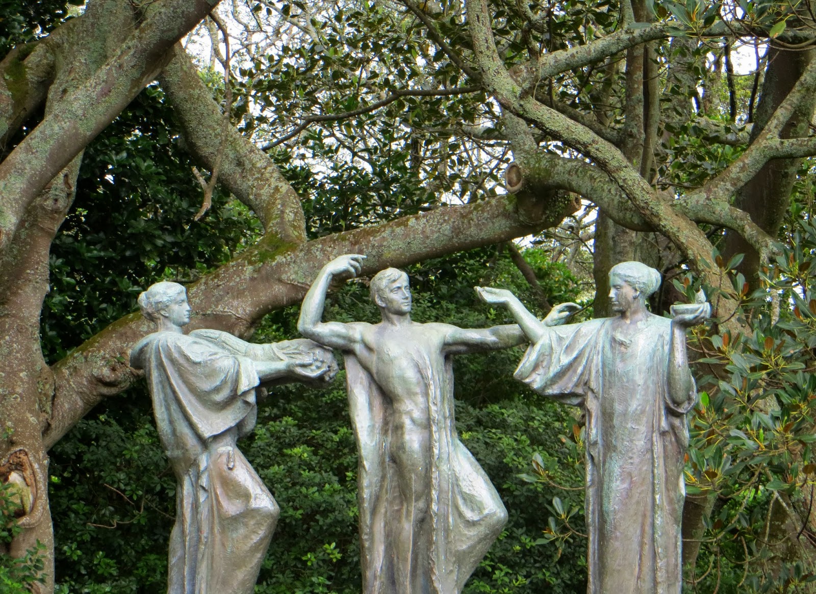
#20 the three bronze figures representing wisdom, fertility and strength

23 May 2012

On the road from Puno to Chivay


I had no idea how impressive the scenery would be as we drove out of Puno in the chilly early morning, heading for the little town of Chivay in the Colca Valley.

Our first stop was at Lagunillas Lake, where the blues of the lake and the sky competed for our attention – which was more blue? The sky was sprinkled with the whispiest of clouds and the lake surface peppered with flamingos – so pretty.


Soon after Lagunillas, we had our first sight of Misti, the active volcano that looms menacingly over Peru’s second largest city, Arequipa. Its shape echoes the cone-like perfection of Japan’s Mt Fuji, and Mt Egmont, in my native New Zealand.


At Pampa Cañahuas, in the Aguada Blanca National Park, we turned off the main Puno-Arequipa highway and made a short stop for a mid-morning snack. On the other side of the highway, there was a huge rocky outcrop, with ancient rock formations that reminded me of Cappadocia, in Turkey.


As we rode on, the skies were breathtakingly huge, the llamas and vicuña dwarfed by the grandeur of the big country that surrounded them. One herd of llamas played follow the leader down a steep hillside.


We stopped again at Patapampa, at 4800 metres, the highest point on our journey. As well as the ubiquitous roadside souvenir sellers, the ground was littered with artificial piles of small rocks. The bus company’s pamphlet said these were placed ‘by travellers and local residents, who place them as part of a ritual related to resting, strength to continue with the trip, protection, health and permission to enter somewhere new.’ I added a small rock to one pile.


At Chivay, we joined Luis the guide and a small group of travellers who would be our companions for the next day and a half. At our charming hotel in the nearby village of Choraque, we ate a delicious lunch and met the local guard 'dog', a llama/alpaca-cross, a critter with attitude. I got spat at quite early on, as did one of the men when he tried to persuade the beast to move away from the entrance gate. ‘My, what big teeth you have!’


In Chivay, after lunch, we explored the town, enjoying the beautiful paintings in its lovely old church, the bartering and banter of the sellers in the local market, the delicately embroidered and very colourful traditional dress of the local women. My friend Marianne and several of our group also enjoyed a warming soak in the local hot pools and, returning to the hotel, we ate a delicious meal and retired quite early to a heated room and comfy beds. What a superb day!